Disasters, Dictators or Data?
Patrick MacLeamy, FAIA
CEO Emeritus of HOK, Co-founder and Chairman Emeritus of buildingSMART International
September 4, 2024
Digital information can converge to help residents improve their cities.
Urban areas often seem unmanageable, with enduring problems of traffic congestion, crime and poor quality of life. Something needs to change for cities to become healthy and welcoming places to live, work and play.
Historical Precedents
Transforming cities is not easy. In fact, the causes of significant historical changes to cities have often been catastrophes. The Great Chicago Fire of 1871 and the San Francisco Earthquake of 1906 are two examples of disasters that reshaped cities. Each led to the creation of vibrant new neighborhoods, parks and waterfronts. Each also led to new fire safety and building codes.
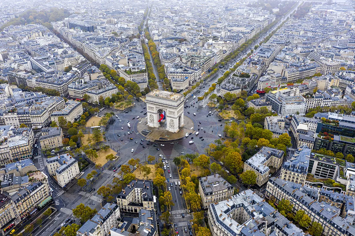
Dictators can also affect change. Napoleon III (Louis Napoleon Bonaparte) ordered that the crooked medieval streets of Paris be made straight to facilitate cannon fire in case of uprisings. The Paris of today is the result. Renaissance-era Pope Sixtus IV began the transformation of Rome from a medieval to a Renaissance city. Much later, Benito Mussolini decreed that the Colosseum be repaired and the Forum be uncovered to restore the glory of the Roman Empire. Rome today is a delightful blend of ancient and Renaissance construction.
Sometimes dictators are not the drivers of change. Some cities remake parts of themselves in order to host the Olympics or a World’s Fair, but such changes are not as widespread or enduring.

Paris is one of the best examples of how a dictator reshaped a city. For military reasons, Emperor Napoleon III had visionary urbanist George-Eugene Haussmann redesign the city’s medieval crooked streets into a star pattern. This allowed cannons to be positioned at the current location of the Arc de Triomphe for straight shots down the twelve radiating streets that converge at L’Etoile.
Another Way
Today, we have the opportunity to use data to transform cities on a similar scale to the transformations that occurred in the aftermath of disasters and dictators; we can harness data from Building Information Modeling (BIM), Geographic Information Systems (GIS) and the Internet of Things (IoT) to improve our cities in broad-based, democratic ways.
Digital data, combined with organizing and advocacy, can empower citizens to redesign their cities. To make this possible, we must harness, combine and make readily available all data gathered by cities’ planning, public works and other municipal departments — including zoning, engineering, utilities, traffic, crime and more. This information is usually scattered and often obscure, but it is time to democratize that data and make it accessible online to the public.
Citizens equipped with information can influence urban design to focus on the needs of people instead of prioritizing public utilities and special interests. Civic-minded, personally invested residents with access to real-time, comprehensive data can become major contributors to the design and future of their cities. In fact, data accessibility should be a key metric when ranking cities: Good cities have good data.
Successful implementation requires making live data available at no cost. As business gurus say, “If you can’t measure it, you can’t improve it.”
We can harness data from Building Information Modeling (BIM), Geographic Information Systems (GIS) and the Internet of Things (IoT) to improve our cities in broad-based, democratic ways.
Democratizing Data
For example, citizens could use traffic accident data to see how features common to low-incident areas can make dangerous intersections safer. Are there correlations between police calls and congestion? Could areas with poorer air quality be improved with greenbelts?
Data-based planning would also make neighborhoods more equitable by identifying food deserts, limited health care facilities, brownfields and similar infrastructure systems. In such a future, planning will be based on data, not politics or prejudice.
Patterns will become more identifiable once real-time civic data is merged with BIM, GIS and IoT, along with satellite and drone images. This information can support grassroots design efforts to improve quality of life in any number of ways: adding shade trees on hot, barren city streets; replacing abandoned buildings or vacant lots with pocket parks; installing new street or traffic lights for greater safety.
Democratizing data holds great potential for cities and urban areas. Amsterdam, Barcelona, Stockholm and Columbus, Ohio, are examples of cities that have digitized data and made it widely available. More cities should follow their example as fully integrated, fully accessible information becomes widespread.
Making proactive change via democratized data is infinitely better than waiting for reactive improvements following disasters or dictators — or both.
By now, we know that the process of digitizing, centralizing and updating data can be daunting. Many cities lack the resources to format existing and incoming data in ways that allow merging all the information — the ability to overlay emergency call maps with air quality maps, for example.
One solution is public/private partnerships that include universities and local businesses. Security concerns are particularly relevant for IoT data collected from personal devices. However, improved access to public data and the ability for it to be integrated with other public information will reap rewards toward creating smarter, safer cities.
Making proactive change via democratized data is infinitely better than waiting for reactive improvements following disasters or dictators — or both.
Patrick MacLeamy, FAIA, is CEO Emeritus of HOK, where he enjoyed a 50-year career at one of the world’s largest design and engineering firms. He is a co-founder and currently serves as Chairman Emeritus of buildingSMART International, a not-for-profit organization that fosters standards for data exchange in the building industry.


